Chasing Peak Foliage:
7 Days Across New England
Seven days of peak fall color: the Kancamagus Highway and Franconia Notch in the White Mountains, Stowe and the Green Mountains of Vermont, the Berkshires, and Acadia National Park in Maine.
Free interactive planner · drag & reorder your days, add stops, map it in minutes
Build your own New England fall trip, drag, reorder & map it.
Drag stops between days, swap scenic drives for hikes, and add your own covered bridges, cider mills, and lighthouses with the place search. The live map and drive times recalculate as you go, so you can chase peak foliage on your exact dates.
Opens a side panel · reorder days, add custom stops, see your route live
Three states, mountains, covered bridges & coast, all in peak color.
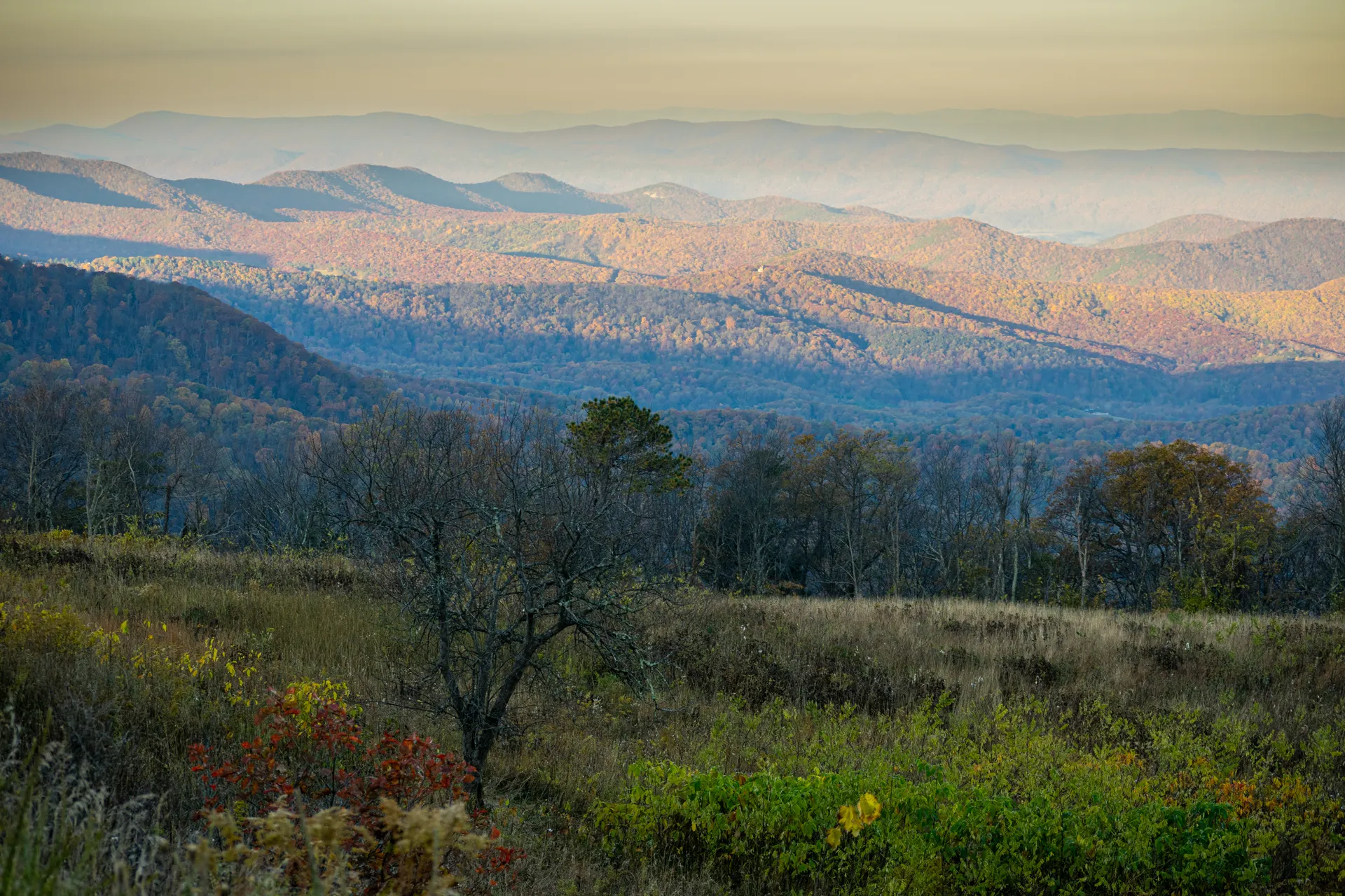
A New England fall road trip is the classic American leaf-peeping pilgrimage, a loop through the White Mountains of New Hampshire, the Green Mountains of Vermont, the Berkshires of Massachusetts, and the rocky coast of Maine. Over a week you can drive the most celebrated scenic byways in the region, hike easy trails into the color, and stop for cider doughnuts and lighthouses along the way.
This 7-day route links the highlights: the Kancamagus Highway and Franconia Notch in the White Mountains, the Mount Washington Auto Road or Cog Railway, Stowe and Smugglers Notch in Vermont with its covered bridges and VT-100, a swing through the Berkshires, and a finale on the coast in Acadia National Park with Cadillac Mountain sunrise, the Park Loop Road, and Jordan Pond.
Timing is everything. Peak foliage moves north to south and high to low, roughly late September in the northern White and Green Mountains to mid-October in the Berkshires and along the coast. Check a foliage map before you lock dates. Peak weekends draw big crowds and inns book out months ahead, so reserve lodging early and start scenic drives at dawn.
Peak foliage weekends are the busiest of the year in New England. Inns and motels in North Conway, Lincoln, Stowe, and Bar Harbor book out months ahead and rates spike, so reserve lodging as early as you can. Mount Washington Auto Road and Cog Railway tickets and any Acadia tours should be booked in advance too, and plan to be on the Kancamagus and Park Loop Road early to beat the leaf-peeping traffic.


Arrive & the Kancamagus Highway
Fly into Boston (BOS), Manchester (MHT), or Portland (PWM) and point the car north for the White Mountains of New Hampshire. Base for the next two nights in North Conway or Lincoln, the gateway towns on either end of the foliage country, then drive the trip's signature stretch.
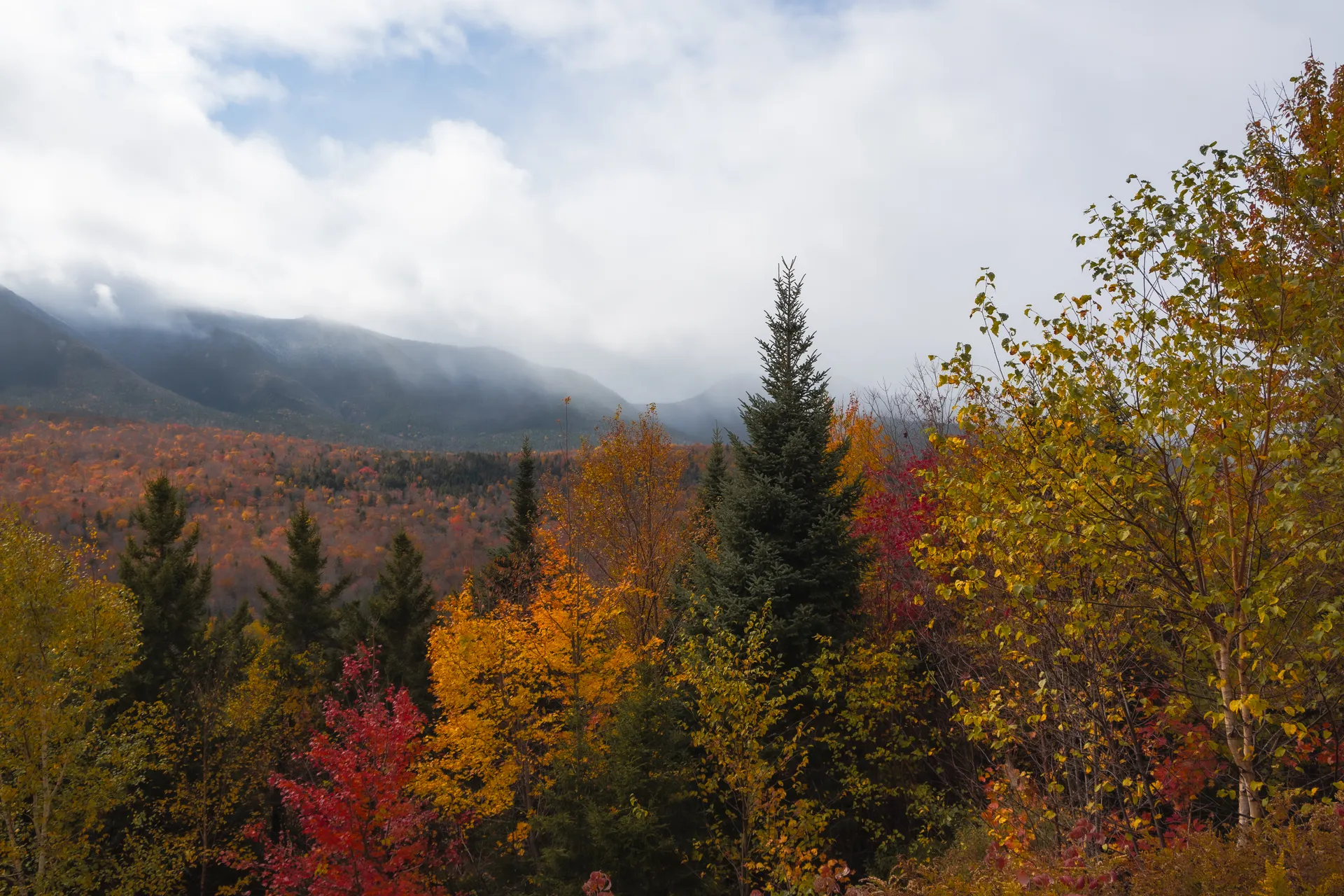
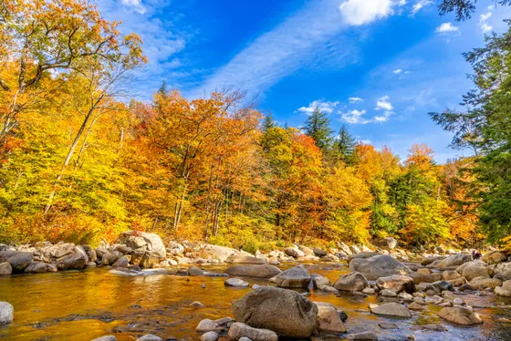
The Kancamagus Highway (NH-112, the "Kanc") is one of the most famous fall drives in America, a 34-mile National Scenic Byway over a 2,855-foot pass through the heart of the White Mountain National Forest with no gas, no services, and wall-to-wall color. Stop at the Sabbaday Falls and Rocky Gorge pullouts, walk a short loop, and time the high points for late afternoon light. Drive it early or late to dodge the leaf-peeping traffic.
- 34 mi · no services · Sabbaday Falls & Rocky Gorge pullouts
- ~0.6 mi RT · easy · waterfall just off the Kanc
- Drive up from BOS, MHT, or PWMBOS ~2.5 hr · MHT ~1.5 hr · PWM ~2 hr to North Conway
- Base in North Conway or LincolnTwo nights in the White Mountains · books far ahead in peak
- There is no gas or services on the Kancamagus Highway. Fill up in Conway or Lincoln before you start, and download offline maps for the pass.
- The Kanc is busiest midday on peak weekends. Drive it at first light or in the last hour of daylight for the best color and the smallest crowds.
- North Conway and Lincoln book out months ahead for foliage weekends. Reserve early, and consider a midweek visit for lower rates and thinner traffic.

Franconia Notch & Mount Washington
Spend the morning in Franconia Notch State Park, the dramatic mountain pass that splits the White Mountains. Walk the Flume Gorge, a boardwalk loop through an 800-foot granite chasm running with waterfalls and framed by color, then ride the Cannon Mountain aerial tramway to a summit panorama over the notch and the Presidential Range.
In the afternoon, climb the highest peak in the Northeast. The Mount Washington Auto Road drives you (or a guided van takes you) to the 6,288-foot summit, or ride the historic Cog Railway up the other side. Mount Washington has some of the worst weather on Earth, so check the summit forecast, dress warmly, and be ready for the view to vanish into cloud. Book Auto Road and Cog tickets ahead in peak season.
- ~2 mi loop · boardwalk through an 800-ft granite chasm
- Cannon Mountain Aerial TramwayTram to a 4,080-ft summit · panorama over the notch
- Mount Washington Auto Road6,288-ft summit · drive or guided van · check summit weather
- Mount Washington Cog RailwayHistoric rack railway up the west side · book ahead in peak
- Mount Washington is famous for extreme weather and can be 30 degrees colder and socked in cloud at the summit. Check the higher-summits forecast before you go up and pack layers.
- The Flume Gorge requires a timed ticket in peak season and the boardwalk is one-way. Buy online ahead and go early to beat the foliage crowds.
- Auto Road and Cog Railway tickets sell out on peak foliage days. Reserve in advance, and note the Auto Road may close in bad weather.
Over to Vermont · Stowe & Smugglers Notch
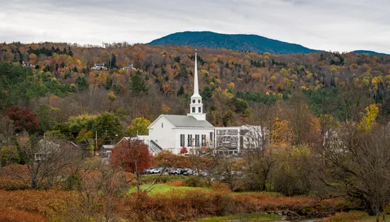
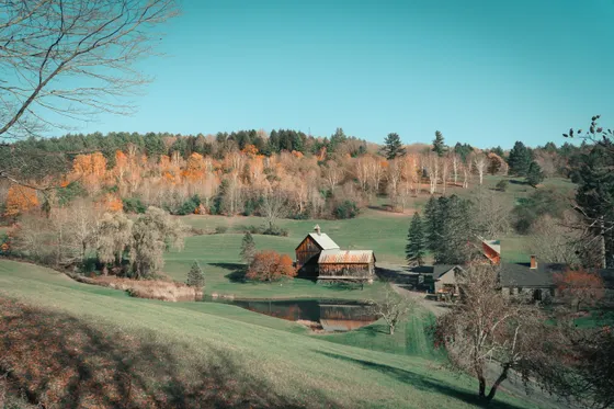
Cross from New Hampshire into Vermont, trading the rugged White Mountains for the softer, rolling Green Mountains. Make your base for two nights in Stowe, the postcard heart of Vermont leaf-peeping, with its white church steeple, the recreation path, and farm stands selling cider and maple everything.
Drive the Smugglers Notch road (VT-108), a narrow, boulder-lined pass that squeezes between Mount Mansfield and Spruce Peak, closed in winter but spectacular in fall. Ride the Stowe gondola or hike a stretch of Mount Mansfield, Vermont's highest peak, for a sweeping view over a quilt of color. Stop at a cider mill or sugarhouse on the way back into town.
- Smugglers Notch (VT-108)Narrow boulder-lined pass below Mount Mansfield · closed in winter
- Stowe gondola, Mount MansfieldRide to Vermont's highest ridgeline · panoramic color
- Mount Mansfield hike or recreation pathHike the high ridge or stroll the easy Stowe rec path
- Base in StoweTwo nights · steeple, cider mills & VT-100 · book far ahead
- The Smugglers Notch road is a tight, twisting squeeze between giant boulders and is not suitable for large RVs or trailers. Take it slow and watch for oncoming traffic.
- Stowe is one of the most popular leaf-peeping towns in New England and books out months ahead for peak foliage weekends. Reserve early or stay nearby in Waterbury.
- Stop at a cider mill or sugarhouse for fresh cider doughnuts and maple syrup. Cold Hollow Cider Mill in Waterbury Center is a classic on the way through.
VT-100, covered bridges & the Green Mountains
Spend a full day on Vermont's most beautiful back road. VT-100 runs the length of the state down the spine of the Green Mountains, threading through small towns, farm fields, and forests that turn every shade of red and gold. It is widely considered one of the best fall drives in the country, so take your time and pull off often.
Hunt down Vermont's famous covered bridges, the red wooden spans over rocky streams that define a New England autumn. Stop at general stores for cider doughnuts, browse a farm stand, and photograph a white church steeple against the hills. Loop back to Stowe for the night, or use the day to begin shifting south toward the Berkshires.
- VT-100 scenic driveVermont's classic foliage road down the Green Mountains
- Vermont covered bridgesRed wooden spans over rocky streams · endless photo stops
- Green Mountains overlooksFarm fields, forests & steeples in peak color
- Second night in StoweStay put, or shift south toward the Berkshires
- VT-100 is a slow, scenic road, not a fast route. Build in extra time, expect to stop constantly for photos, and do not plan a tight schedule around it.
- Many covered bridges are on side roads off VT-100. Search for them in the planner or a foliage map, and respect that some sit on private or one-lane roads.
- Country general stores are part of the experience. Stop for cider doughnuts, local cheese, and maple syrup, and fill the tank in towns since stations thin out between them.
The Berkshires & the long drive to the coast
Drop south into the Berkshires of western Massachusetts, the gentle hills where fall color usually peaks a week or two later than the northern mountains. Drive the Mohawk Trail (MA-2) with its hairpin turn and overlooks, or take in the view from the summit of Mount Greylock, the highest point in the state. The Berkshires pair their foliage with art museums, country inns, and farm-to-table villages like Stockbridge and Lenox.
This is a transition day with real miles. From the Berkshires it is a long but scenic haul north and east toward the Maine coast and Acadia National Park. Break the drive in Portland (PWM) for lobster and a harbor walk if you like, then push on to Bar Harbor, your base for the final two nights. Plan the driving for daylight and book your Bar Harbor lodging well ahead.
- Mohawk Trail (MA-2)Berkshires scenic byway · hairpin turn & ridge overlooks
- Mount Greylock summitHighest point in Massachusetts · drive or hike to the view
- Drive to the Maine coastLong scenic haul to Bar Harbor · break in Portland for lobster
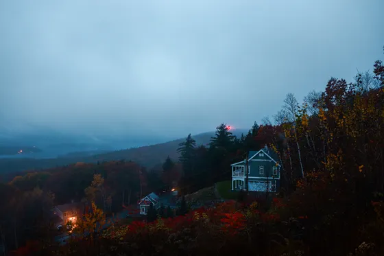
- Base in Bar HarborTwo nights at the gateway to Acadia · books far ahead
- The Berkshires usually hit peak color a week or two after the northern mountains, so they are a good late-trip stop if the north has already turned.
- This is the longest driving day of the trip. Start early, plan fuel and food stops, and aim to reach Bar Harbor before dark to settle in for Acadia.
- Bar Harbor is the busiest it gets all year in foliage season. Reserve your room well ahead, and consider Ellsworth or Trenton if Bar Harbor is full.
Acadia · Cadillac Mountain sunrise & the Park Loop Road
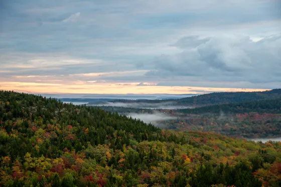
Wake before dawn for one of the great American sunrises. From October through early March, the summit of Cadillac Mountain is among the first places in the United States to see the sun, and on a clear morning the light spreads over the islands and the sea. The summit road requires a timed vehicle reservation in season, so book it on recreation.gov ahead of time.
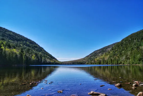
Spend the day on the Park Loop Road, the 27-mile scenic drive that strings together Acadia's greatest hits: Sand Beach, Thunder Hole, the pink granite cliffs of Otter Point, and Jordan Pond. Walk the easy Ocean Path along the cliffs, then finish at the Jordan Pond House for the classic view of the Bubbles and a popover on the lawn. This is where the mountains meet the sea, and the fall color runs right down to the shore.
- Among the first US sunrises Oct–Mar · timed vehicle reservation
- 27-mi scenic loop · Sand Beach, Thunder Hole, Otter Point
- ~4 mi RT · easy · cliffs from Sand Beach to Otter Point
- Mirror-still pond · Jordan Pond House popovers on the lawn
- Cadillac Mountain summit road requires a timed vehicle reservation in season, and sunrise slots go fast. Book on recreation.gov as soon as the window opens, well ahead of your dates.
- Acadia charges about $35 per vehicle for a 7-day pass, or use an America the Beautiful pass. Get it ahead of time to skip the line.
- The Park Loop Road is one-way for much of its length and parking at Sand Beach, Thunder Hole, and Jordan Pond fills early. Start at dawn, or use the free Island Explorer shuttle in season.
Lighthouses, carriage roads & the drive home
On your last morning, slow down for the coast. Drive out to the Bass Harbor Head Light on the quieter side of Mount Desert Island, the most photographed lighthouse in Maine, perched on pink granite above the surf. If you have energy, walk or bike a stretch of Acadia's historic carriage roads, the crushed-stone paths and graceful stone bridges built by the Rockefellers, gorgeous under the fall canopy.
Then point the car home. Getting home: Portland (PWM) is about 3 hours from Bar Harbor and the closest major airport, while Boston (BOS) is roughly 5 hours and Manchester (MHT) about 4.5. Top off the tank, grab one last lobster roll, and leave with daylight to spare for the drive back to your airport.
- Maine's most photographed lighthouse · pink granite & surf
- Crushed-stone paths & stone bridges · walk or bike
- Getting home: PWM, MHT, or BOSPWM ~3 hr · MHT ~4.5 hr · BOS ~5 hr from Bar Harbor
- Bass Harbor Head Light parking is small and fills fast, especially at sunset. Go early in the morning, and follow the short paths down to the rocks for the classic view.
- The carriage roads are car-free and ideal for an easy walk or a bike ride under the fall canopy. Bikes can be rented in Bar Harbor if you did not bring your own.
- It is a long drive back to the airport. Portland is the closest at about 3 hours, Manchester about 4.5, and Boston about 5, so fuel up and leave with plenty of daylight.
Now build your New England fall trip.
You've seen all seven days. Open the free drag-and-drop planner and tune it for your dates, your pace, and whether you base in North Conway, Stowe, or Bar Harbor.
What we actually learned chasing the color.
Time your dates to the foliage map
Peak color moves north to south and high to low, roughly late September in the northern White and Green Mountains to mid-October in the Berkshires and along the Maine coast. Check a live foliage map a week or two out before you lock in dates, and build in flexibility because the peak shifts every year.
Book lodging months ahead
Peak foliage weekends are the busiest of the year in New England. Inns and motels in North Conway, Lincoln, Stowe, and Bar Harbor sell out months ahead and rates spike. Reserve early, consider midweek for lower prices and thinner crowds, and have a backup town in mind.
Drive scenic roads early or late
The Kancamagus Highway, VT-100, and Acadia's Park Loop Road all clog with leaf-peeping traffic midday on peak weekends. Drive them at first light or in the last hour of daylight for the best color, the smallest crowds, and the easiest parking at popular pullouts.
Reserve timed tickets in advance
Cadillac Mountain summit needs a timed vehicle reservation on recreation.gov, and the Flume Gorge, Mount Washington Auto Road, and Cog Railway all sell out in peak season. Book these ahead of your dates so a sold-out slot does not derail a day.
Fuel up and watch the gaps
There is no gas on the Kancamagus Highway and stations thin out on the back roads of Vermont and Down East Maine. Fill the tank in towns before long scenic stretches, and download offline maps since cell service drops in the mountains and on the byways.
Pack layers and rain gear
New England fall swings from warm afternoons to near-freezing summits, and Mount Washington can be brutal. Bring warm layers, a rain shell, and good shoes for short hikes, and check the higher-summits forecast before any mountain-top stop.
Everything you'll actually want to know.
Ready to go? Get your
New England fall route.
Scenic byways and mileages, the gateway towns to base in, timed-ticket reservations, drive times from Boston, Manchester, and Portland, and the foliage timing you need to catch peak color across three states.
Instant book · Free cancellation · Secure payment via Stripe

Planning this trip?
Save it, share it with your crew, or find travelers heading the same way.

Liked this itinerary?
What other travelers are saying
Be the first to leave a tip or question for the next traveler.