Big Bend in 4 Days:
Chisos Peaks & the Rio Grande
Four days hiking in Big Bend National Park: the Window Trail and Lost Mine in the Chisos, the Emory Peak summit, Santa Elena Canyon, and a Rio Grande raft trip.
Free interactive planner · drag & reorder your days, add stops, map it in minutes
Build your own Big Bend trip, drag, reorder & map it.
Drag stops between days, swap hikes, and add your own canyons and overlooks with the place search. The live map and drive times recalculate as you go, and we'll warn you before you build a day no one survives in the desert heat.
Opens a side panel · reorder days, add custom stops, see your route live
One park, mountains, river & desert, all in West Texas.
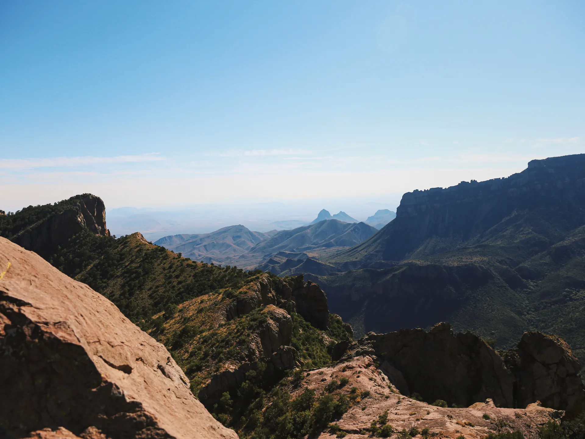
Big Bend National Park is one of the largest and most remote parks in the lower 48, an 800,000-acre sweep of the Chihuahuan Desert wrapped around the Chisos Mountains and bordered for 118 miles by the Rio Grande. It is a long way from anywhere, and that is exactly why the night skies, the canyons, and the silence feel like nowhere else.
This 4-day route is built around hiking in Big Bend National Park: the Window Trail and Lost Mine in the cool Chisos Basin, the strenuous Emory Peak summit, and Santa Elena Canyon where 1,500-foot limestone walls drop straight to the river. You'll mix the best hikes with a Rio Grande raft trip, the Ross Maxwell Scenic Drive, and a soak at the historic Hot Springs.
November through March is the prime season, with comfortable days and cool nights. Spring (especially March) is beautiful but busy. Summer is dangerous: desert temperatures regularly top 100°F, and it is even hotter and more extreme down along the river, so save low-elevation hikes for early morning.
Chisos Mountains Lodge is the only in-park lodging and books up far ahead, often months out for prime season weekends. If it is full, base in Terlingua or Marathon and drive in. There is no gas inside the park interior, so fill up at Panther Junction or Study Butte, and bring far more water than you think you need.


Drive in & the Chisos Basin · the Window Trail
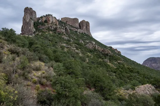
Big Bend is genuinely remote: plan on about 3.5 hours from Midland (MAF) or 4.5 hours from El Paso (ELP), with long empty stretches and little to no cell service. Stop for gas in Marathon or at Study Butte before you commit to the park interior, then climb the steep, winding road up into the Chisos Basin, a cool mountain bowl ringed by peaks and the heart of the park's hiking.
Settle in, then hike the Window Trail (about 5.6 miles round trip, moderate) down to the Window pour-off, a dramatic V-shaped notch where the entire basin drains and frames the desert far below. Time it for late afternoon so you are at the Window for sunset, then walk back up to the basin as the light goes gold.
- ~5.6 mi RT · moderate · downhill out, uphill back · sunset views
- Fill up at Panther Junction or Study ButteNo gas in the park interior · top off before the Chisos road
- Chisos Basin overlookCool mountain bowl · the only in-park lodge and campground
- Stay in the Chisos BasinChisos Mountains Lodge is the only in-park lodging · books far ahead
- There is no gas in the park interior. Fill up in Marathon, Study Butte, or at the Panther Junction station before you head up to the Chisos.
- The Window Trail goes downhill on the way out and uphill on the way back, so save energy and water for the return climb.
- Chisos Mountains Lodge is the only lodging inside the park and books months ahead. If it is full, base in Terlingua or Marathon.
The best Chisos hike: Lost Mine Trail

Today is your big Chisos hike. The standout is the Lost Mine Trail (about 4.8 miles round trip, moderate), widely rated the best views-per-mile hike in the park, climbing to a ridgeline panorama over Juniper Canyon and the Sierra del Carmen across the river in Mexico. If you only do one Chisos hike, make it this one.
Want a bigger day instead? Strong, early-starting hikers can swap Lost Mine for Emory Peak (about 10.5 miles round trip, strenuous), the highest point in the park at 7,825 feet, with a short rock scramble to the summit and a 360-degree view. Pick one or the other, not both: roughly 15 miles of Chisos climbing in a single day is too much for most people. Carry plenty of water, start at first light, and be off the mountain well before dark.
- ~4.8 mi RT · moderate · best views per mile · start early
- ~10.5 mi RT · strenuous · 7,825 ft summit · do this INSTEAD of Lost Mine, not on top of it
- Carry plenty of waterDesert and altitude · no water on the trails · start at first light
- Second night in the Chisos BasinStay put so you can hit the trailhead at dawn
- Lost Mine has the best views per mile in the park. The Lost Mine trailhead parking lot is small and fills early, so arrive at dawn.
- Emory Peak (about 10.5 miles, strenuous) is the alternative for fit hikers who want a full day. Do it instead of Lost Mine, not in addition: roughly 15 miles of climbing in a day is not realistic for most people.
- There is no water anywhere on these trails. Pack everything in and turn around in time to be off the mountain well before dark.
The Rio Grande · Hot Springs, Boquillas & a raft trip
Drop down out of the mountains to the Rio Grande, the river that gives Big Bend its name and forms the park's 118-mile border with Mexico. Soak in the Hot Springs Historic District, where 105°F mineral water bubbles up beside the river inside the foundation of an old bathhouse, then walk the short Boquillas Canyon Trail (about 1.4 miles round trip) into a deep canyon where the cliffs echo.
For the best way to experience the river, book a guided Rio Grande raft or canoe trip with Far Flung Outdoor Center, the park's long-running river outfitter based in Terlingua. A half-day float drifts you between canyon walls you simply cannot reach on foot. Remember this side of the park sits at low elevation and runs hot, so do river activities in the morning and carry plenty of water.
- Guided Rio Grande raft / canoe trip · the park's river outfitter · book ahead
- 105°F mineral water beside the river · short walk in · go early
- ~1.4 mi RT · easy · echoing canyon walls along the river
- Stay near the river or in TerlinguaRio Grande Village campground, or drive out to Terlingua for the night
- The river side of the park is low and hot. Do the Hot Springs, Boquillas, and any raft trip in the morning before the heat builds.
- Far Flung Outdoor Center is the park's established river outfitter out of Terlingua. Reserve a guided raft or canoe trip ahead, especially on weekends.
- The Hot Springs is a short walk from a rough dirt parking lot. Go early to have the 105°F pool to yourself before crowds arrive.


Ross Maxwell Scenic Drive & Santa Elena Canyon
Save the most scenic drive in the park for last. The Ross Maxwell Scenic Drive winds about 30 miles southwest through dramatic desert and volcanic country, with pullouts at Sotol Vista, Mule Ears, and the Tuff Canyon overlook, before dead-ending at the river. Take your time: this is one of the best stretches of pavement in West Texas.
The road ends at the park's signature finale, the Santa Elena Canyon Trail (about 1.7 miles round trip, easy to moderate), where 1,500-foot limestone walls rise straight up from the Rio Grande as the river slices between the United States and Mexico. Getting home: from here it is roughly 3.5 hours back to Midland (MAF) or 4.5 hours to El Paso (ELP), so top off your gas at Study Butte or Panther Junction and start the long drive out with daylight to spare.
- ~30 mi · Sotol Vista, Mule Ears, Tuff Canyon · the best park drive
- ~1.7 mi RT · easy to moderate · 1,500-ft canyon walls · check water levels
- Getting home: Midland or El PasoMAF ~3.5 hr · ELP ~4.5 hr · fuel up before the long drive out
- The Santa Elena Canyon Trail crosses Terlingua Creek near the start. After rain it can be muddy or impassable, so check conditions at a visitor center.
- Drive the Ross Maxwell Scenic Drive slowly and stop at the pullouts. Sotol Vista at sunset is one of the best views in the park.
- It is a long, remote drive back out. Fill up at Study Butte or Panther Junction and leave with plenty of daylight for the 3.5 to 4.5 hour airport run.
Now build your Big Bend trip.
You've seen all four days. Open the free drag-and-drop planner and tune it for your dates, your pace, and whether you base in the Chisos Basin, Terlingua, or Marathon.
What we actually learned in the desert.
Pay the entrance fee or bring your pass
Big Bend charges about $30 per vehicle for a 7-day pass. The annual America the Beautiful pass ($80) also covers entry and pays off fast if you visit other national parks. Pay at the entrance station or online ahead of time.
Fill up before the park interior
There is no gas in the heart of the park. Fuel stations sit at Panther Junction inside the park and in the gateway towns of Study Butte and Marathon. Top off your tank before every long stretch, because the next pump can be 60 miles away.
Bring far more water than you think
The Chihuahuan Desert is brutally dry. Carry at least a gallon of water per person per day, and 3 to 4 liters on a summit hike. There is no water on the trails. Heat is the number one danger here, especially down along the river.
Expect almost no cell service
Cell coverage is nearly nonexistent across the park. Download offline maps, screenshot your trailheads, and tell someone your plan before you go. Visitor centers at Panther Junction and Chisos Basin have the most reliable information.
Go November through March
Winter and late fall bring comfortable days and cool nights, the best time for hiking. Spring, especially March, is gorgeous but crowded. Summer is dangerous: desert temperatures top 100°F and the river corridor is even more extreme, so hike at dawn.
Lodging is scarce, so book early
Chisos Mountains Lodge is the only lodging inside the park and books months ahead for prime season. Otherwise base in Terlingua or Marathon and drive in, or reserve a campsite through recreation.gov well in advance.
Everything you'll actually want to know.
Ready to go? Get your
Big Bend hiking route.
Trailheads and mileages, the only in-park lodge, gas stops, raft outfitter, drive times from Midland and El Paso, and the river-day timing you need to hike Big Bend safely.
Instant book · Free cancellation · Secure payment via Stripe


Planning this trip?
Save it, share it with your crew, or find travelers heading the same way.

Liked this itinerary?
What other travelers are saying
Be the first to leave a tip or question for the next traveler.