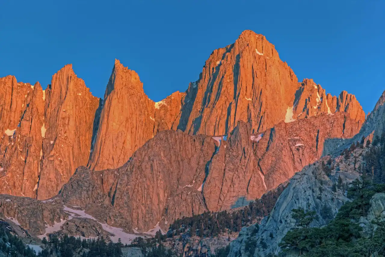
The John Muir Trail (JMT) covers 211 miles through the heart of the Sierra Nevada — from Yosemite Valley to the summit of Mt. Whitney, the highest peak in the contiguous US at 14,505 ft. The trail passes through three national parks (Yosemite, Kings Canyon, Sequoia) and crosses five High Sierra passes above 11,000 ft. It is widely considered the most spectacular long-distance trail in North America.
Key Stats
- Total distance: 211 miles (340 km)
- Typical thru-hike duration: 18–25 days
- Total elevation gain: ~47,000 ft
- Highest point: Mt. Whitney summit, 14,505 ft
- Best season: Late June through September (July–August peak)
- Direction: Most hikers go north-to-south (Yosemite → Whitney Portal) for permit logistics and sun direction on climbs
Permits
Permits are the hardest part of planning the JMT. You need a wilderness permit for your trailhead entry point. The two main options:
- Happy Isles (Yosemite Valley): The most popular start. Only 45 JMT permits per day. Apply in the lottery at recreation.gov in January/February for the following summer. Competition is intense — apply for multiple dates and entry points.
- Tuolumne Meadows: Fewer applicants, starts at ~8,600 ft (easier acclimatization). Walk 20 miles north to connect with the JMT or hike south directly.
- Alternative entries: Lyell Canyon, Glacier Point (shorter permit queues). All join the JMT within the first 30 miles.
- Whitney Zone permit: Separate permit required to exit at Whitney Portal (included if you hold a JMT permit with Whitney as your exit).
Resupply Points
Most hikers resupply 2–3 times. Options from north to south:
- Tuolumne Meadows Store (mile ~21): Limited but reliable. Good for topping off fuel and snacks.
- Vermilion Valley Resort / VVR (mile ~90): Resort and ferry across Edison Lake. Full resupply boxes accepted. Burger and beer reward.
- Muir Trail Ranch / MTR (mile ~115): Private ranch, bucket pickup only. Reserve bucket space in advance — fills up fast. Cash economy inside.
- Lone Pine / Independence (mile ~175): Hitch from Kearsarge Pass trailhead (11 miles off-route). Town has a full grocery store and motels.
The Five High Passes
- Donahue Pass (11,056 ft): First major pass out of Yosemite. Gradual approach, stunning views back toward Lyell Canyon.
- Silver Pass (10,900 ft): Rocky and exposed. Often has snow until late June.
- Selden Pass (10,900 ft): Gentle on both sides. Beautiful Heart Lake just below.
- Muir Pass (11,955 ft): Most remote and dramatic. The stone Muir Hut sits at the top. Snow lingers here the longest — check current conditions.
- Forester Pass (13,153 ft): Highest point on the JMT/PCT outside of Whitney. Steep chute on the north side can hold dangerous ice well into July. Microspikes essential before late July.
- Mt. Whitney (14,505 ft): The finish. Most hikers summit at dawn and descend to Whitney Portal for a shuttle.
Gear Essentials
- Bear canister: Required in Yosemite and most of the Sierra. BV450 or BV500 are the standard choices.
- Water filter: Sawyer Squeeze or BeFree. The Sierra has abundant water — you'll filter daily.
- Microspikes: Essential for early-season crossings of Forester and Muir passes.
- Trekking poles: Almost universal on the JMT — critical for pass descents and creek crossings.
- Sun protection: High altitude sun is brutal. Hat, sunscreen, and sun-protective clothing matter more than most hikers expect.
- Layering system: Temperatures can drop below freezing at elevation even in August. A puffy jacket and rain shell are non-negotiable.
Practical Tips
- Acclimatize first: Spend 2–3 nights above 8,000 ft before starting. Altitude sickness at Forester Pass (13,153 ft) is no joke if you flew in the day before.
- Shuttle logistics: Leave a car at Whitney Portal or pre-arrange a pickup. KART bus connects Lone Pine to Bishop. Getting back to Yosemite Valley from Whitney Portal takes a full day.
- Water crossings: Early-season snowmelt turns creek crossings dangerous through June. The crossing below Forester Pass is the most notorious — wait until July or bring trekking poles and unbuckle your pack hip belt.
- Leave No Trace camps: Camp 100 ft from water and 200 ft from trail. The Sierra is increasingly impacted — pick already-impacted sites.
- Best online resource: The Yosemite Conservancy JMT guide and Halfway Anywhere's annual survey of JMT hikers.
Plan the full trip
High Sierra · Yosemite to Reds Meadow
Where to stay
Red's Meadow Resupply Base
Tuolumne Meadows Access · Mono Lake
Mt. Whitney Portal · End Point

Did this guide help you?
Want our free Google Maps of the best outdoor spots?
A hand-picked Google Maps list of the best hiking, kayaking, and camping spots, scenic viewpoints, and other outdoor activities across the US, sent straight to your inbox.