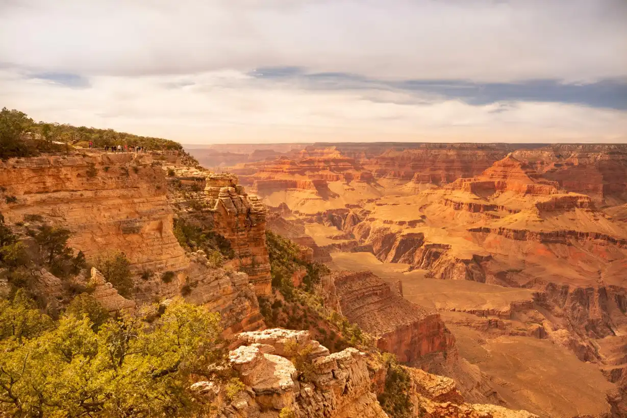
The Grand Canyon Rim to Rim is 24 miles across, dropping 4,700 feet from the South Rim to the Colorado River and climbing 5,700 feet to the North Rim. Most hikers complete it in 2–3 days with overnight camps at Bright Angel Campground and Cottonwood Camp. A very fit, experienced hiker can do it in one day — but the NPS strongly advises against it in summer. Choose your direction, your time frame, and understand the heat before you go.
Overview
- Total distance: 24 miles one-way (South to North) or 21 miles (North to South)
- Total elevation: -4,700 ft / +5,700 ft south to north; reversed going the other way
- Difficulty: Strenuous — one of the most physically demanding day hikes/backpacking routes in the US
- Best season: May–June and September–October (avoid July–August canyon heat of 110°F+)
- Permit required: Yes for overnight camping. No permit for day hiking.
Which Direction: South-to-North or North-to-South?
Most hikers go South to North for one key reason: the North Rim bus shuttle (Trans-Canyon Shuttle) runs from North Rim back to South Rim once daily in season. Going North to South means arranging your own car shuttle or hitchhiking from the South Rim to the North Rim before starting.
- South-to-North: South Kaibab Trail down (4,860 ft descent, 7.1 miles to Colorado), North Kaibab Trail up (5,760 ft ascent, 14 miles to North Rim). This direction saves your legs on the climb.
- North-to-South: North Kaibab down, Bright Angel up. Bright Angel has water stations every 1.5 miles — significantly safer in heat than South Kaibab (no shade, no water).
- The classic route: South Kaibab down / Bright Angel up (20 miles) — stays on South Rim. Popular for non-through hikers.
The South Kaibab Trail
- Distance: 7.1 miles to Colorado River Suspension Bridge
- Elevation loss: 4,860 ft
- Water: NONE on the trail. Only at Bright Angel Campground at the bottom.
- Shade: Almost none — exposed ridgeline the entire way
- Key viewpoints: Ooh Aah Point (0.9 miles), Cedar Ridge (1.8 miles — good turnaround for day hikers), Skeleton Point (3 miles — incredible canyon panorama), Tip Off (4.4 miles — last view before descending inner gorge)
- Mule right-of-way: Move to the uphill side of the trail, face the canyon wall, and stay still. Mules run this trail daily and have right-of-way. Don't spook them.
Bright Angel Campground (Canyon Floor)
- Elevation: 2,480 ft (river level)
- Facilities: Flush toilets, tap water, emergency phone, nearby Bright Angel Creek for swimming
- Permit: Required — recreation.gov lottery in October for the following year's May/June/September/October dates
- Phantom Ranch: The only lodge below the rim. Cabins and dorms, hearty dinner and breakfast, lemonade at the canteen. Books solid 14 months in advance. Check for cancellations within 6 months.
- Temperature: The canyon floor is typically 20°F hotter than the South Rim. At 2,480 ft elevation with no shade, this matters enormously in summer.
The North Kaibab Trail
- Distance: 14 miles to North Rim (from Colorado River bridge)
- Elevation gain: 5,760 ft
- Water: Cottonwood Camp (mile 4.2 from river) and Manzanita Rest Area (mile 9.7). Roaring Springs year-round.
- Key stops: Bright Angel Creek corridor (lush riparian — cottonwoods, willows, deer), Ribbon Falls (mile 5.7 — 100-ft waterfall with mossy grotto, 0.6 miles off-trail), Cottonwood Camp (mile 4.2 — best midpoint camp)
- Upper section: The final 4 miles from Supai Tunnel to the North Rim passes through Kaibab limestone cliffs and the most dramatic upper-canyon formations. This is the hardest section — steep switchbacks after an already long day.
Cottonwood Campground
- Elevation: 4,080 ft
- Distance from river: 4.2 miles (North Kaibab)
- Facilities: Flush toilets (seasonal), tap water, nearby Bright Angel Creek
- Best use: Night 2 camp on 3-day rim-to-rim
- Morning hiking tip: Leave Cottonwood by 6am for the North Rim push in summer. The upper canyon gets exposed sun by 9am.
Rim-to-Rim Permit Strategy
- Lottery: Opens October 1 on recreation.gov for permits 4 months ahead (Oct = February permits, etc.). Most competitive slots are spring and fall weekends.
- 3-month advance: Individual permits released 3 months before the trip date. Set a calendar reminder.
- Walk-up permits: Available at Backcountry Information Center on South Rim at 8am daily. Line up by 6am for peak season dates.
- Bright Angel Camp fills first: If Bright Angel is unavailable, Cottonwood is almost always available. A two-night trip stopping at Cottonwood both ways works if Bright Angel is full.
Heat Management — The Most Important Section
More people are emergency-evacuated from the Grand Canyon than any other national park. The primary cause is heat exhaustion, usually from hiking up the South Kaibab in midday heat.
- Hike canyon trails before 10am and after 4pm in summer. Rest during midday heat — this is not optional in July/August.
- Carry minimum 1 liter of water per hour of hiking in summer. More if above 90°F.
- Electrolytes matter as much as water — drink Gatorade or use electrolyte tablets, not just water, on long descents/ascents.
- Know the symptoms of heat exhaustion: stop sweating, confusion, rapid pulse. Douse with water and seek shade immediately. This becomes heat stroke within minutes if untreated.
- The South Kaibab is exposed with no shade and no water. Do not hike it up in summer afternoons. Bright Angel has water every 1.5 miles and more shade — if heat is a concern, use Bright Angel for the ascent.
Trans-Canyon Shuttle (Rim Transfer)
- Runs twice daily from North Rim to South Rim (4.5 hours, $90/person one-way)
- Departs North Rim at 7am and 2pm; departs South Rim at 8am and 1:30pm
- Runs mid-May through mid-October (North Rim closes in winter)
- Book well in advance: trans-canyonshuttle.com
Plan the full trip
Arizona · North Rim to South Rim
Northern Arizona · Grand Canyon National Park
Where to stay
South Rim · Inside Park
North Rim · Open May–Oct
Canyon Bottom · Permit required

Did this guide help you?
Want our free Google Maps of the best outdoor spots?
A hand-picked Google Maps list of the best hiking, kayaking, and camping spots, scenic viewpoints, and other outdoor activities across the US, sent straight to your inbox.