Gifford Pinchot National Forest stretches across 1.3 million acres of southwest Washington, wrapping around two massive volcanoes and protecting some of the Pacific Northwest's most varied wilderness. Mount Adams rises 12,281 feet on the eastern edge; the Goat Rocks Wilderness straddles the Cascades crest; and the Indian Heaven Wilderness offers a high-elevation lake district that most hikers have never heard of. This is the forgotten corner of the Washington Cascades — stunning, accessible from Portland, and rarely crowded.
Overview
- Location: Southwest Washington — closest cities Portland (OR) and Vancouver (WA)
- Passes required: Northwest Forest Pass ($5/day or $30/year) at most trailheads
- Wilderness permits: Self-issue at most trailheads; no quota system currently for most areas
- Best season: July through October (many trails snowbound June and earlier)
- Forest service info: Mt. Adams Ranger District, Trout Lake WA
Mount Adams
South Climb Route — 12 miles round trip
The most straightforward glaciated volcano climb in Washington. The South Climb from Cold Springs Trailhead (5,600 ft) follows the Suksdorf Ridge to the false summit and continues to the true summit at 12,281 ft. No technical equipment required July–August, though crampons and an ice axe are recommended. A Cascade Volcano Pass is required May 1–October 31 ($10/person); purchase at recreation.gov. The round trip takes 8–12 hours. Start at first light.
Round-the-Mountain Trail — 35 miles loop
A multi-day backpacking loop encircling Mount Adams through four wilderness areas, crossing glacial streams, lava flows, and subalpine meadows. The Killen Creek segment on the north side is the most spectacular. Most hikers take 3–4 days. Camping is dispersed — no established sites on much of the route. Water from glacial streams; filter everything.
Goat Rocks Wilderness
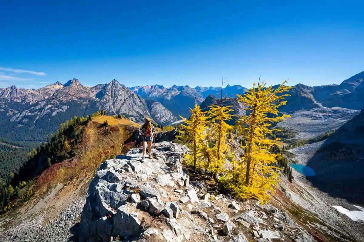
Snowgrass Flat + Goat Ridge Loop — 13 miles
The signature hike in Goat Rocks. Snowgrass Flat is a broad subalpine meadow at 6,500 feet, ringed by wildflowers in late July and early August. The Goat Ridge loop adds 360-degree views of Rainier, Adams, Hood, and St. Helens from the ridge crest. The PCT crosses through here — expect to share the trail with thru-hikers in summer. Access from Chambers Lake TH via Forest Road 21.
PCT Through the Knife Edge — 8 miles (point to point)
The Pacific Crest Trail traverses the Goat Rocks Wilderness along the "Knife Edge" — a narrow ridge at 7,600 feet with exposure on both sides and views of five volcanoes. The section between White Pass and Snowgrass Flat is among the finest PCT miles in Washington. Car shuttle required; access from US-12 at White Pass.
Indian Heaven Wilderness
A high plateau at 5,000–5,700 feet dotted with 150+ lakes, the Indian Heaven Wilderness is one of Washington's best kept secrets. The Berry Fields Loop (16 miles) crosses through huckleberry meadows that are spectacular in late August and September. Day hikers use the Thomas Lake trailhead for an easy 4-mile sampler of lakes and open meadows. Access via Forest Road 24 from Trout Lake.
Day Hike Picks by Difficulty
Easy
- Dry Creek Trail: 4 miles round trip through old-growth forest. Trout Lake area.
- Thomas Lake Loop (Indian Heaven): 4 miles. Multiple alpine lakes, minimal elevation gain.
- Sleeping Beauty: 4.5 miles round trip. Small summit above the Wind River valley with views of Adams and Hood.
Moderate
- Stagman Ridge to Lookout Mountain: 8.4 miles round trip. Old fire lookout above Adams meadows.
- High Camp (Mt. Adams): 5 miles to 6,000-foot high camp below glaciers. Not the summit — just the approach, accessible to most hikers.
Strenuous
- Mt. Adams South Climb: 12 miles, 6,700 ft gain. Permit required.
- Snowgrass Flat + Goat Ridge Loop: 13 miles, 2,800 ft gain.
Best Time to Visit
- July–August: Peak season. Wildflowers in Snowgrass Flat and Indian Heaven. All trails accessible. Mt. Adams climb in best condition.
- September: Huckleberry season in Indian Heaven — exceptional. Crowds drop, weather still reliable. Best colors of the year.
- October: Fall color in the valleys. Higher trails may get early snow. Check road conditions before driving forest roads.
Getting There
From Portland: 1.5–2 hours north on I-84, then north on US-14 along the Columbia River. Trout Lake is the primary gateway community for Mt. Adams and Goat Rocks. White Pass (US-12) is the north entrance. Forest roads require a high-clearance vehicle in some areas — check the Gifford Pinchot NF road conditions before departure.

Did this guide help you?
Want our free Google Maps of the best outdoor spots?
A hand-picked Google Maps list of the best hiking, kayaking, and camping spots, scenic viewpoints, and other outdoor activities across the US, sent straight to your inbox.